Scanning into Areas
Now, using the example file as before, the number of buildings in each „Area of Designated Use“ shall be written into the name BEZ of the respective area. The settings are:
| Object Type: | Building |
|---|---|
| Action/Sum in: | Areas |
| Target Object: | Areas of Designated Use |
| Attribute: | Name (BEZ) |
Example
Path: Examples\Extras\SmallCity02.cna
With these settings and e.g. for attribute 1 all attributes of the object type „Area of Designated Use“ can be accessed. For each area, the sum of the specified attribute is assigned to each „Area of Designated Use“. By selecting the name (BEZ) the value is written into the „Name“ box of the land uses.
When just counting, the „Formula for Summation“ could be set to 1 (one). In this case, however, buildings on the border of the areas will be counted full, causing the sum all buildings counted into the areas to become larger than the real number of buildings in the entire project.
In order to keep the final number constant, a building crossing the border of an area must be counted only with its side part (being < 1, corresponding to the area part of the building inside the area of land use). Therefore, the expression „prop“ is used in the „Formula for Summation“.

After confirming with OK the number of buildings are written into in the „Name box“ of the land uses.
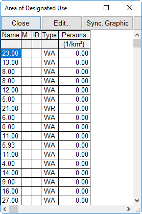
Table Area of Designated Use showing the numberof buildings inside on column „Name“
Summation of Facade Points into Building Evaluation Symbols
The summation of object attributes into specified areas is usually carried out based on the geometric location. This means that the objects scanned for must lay geometrically within the target object type. When summing up facade points into building evaluations, however, the summation occurs per building concerned and not per geometry. There is e.g. useful in conjunction with the noise scoring of building evaluation symbols being addressed to the buildings via Object-Scan.