CadnaA 2023
Features
- Multi-selection of several objects possible, e.g.
- drag frame with right mouse button pressed
- add objects to multi-selection: keep CTRL- key pressed and drag frame in 2D view with right mouse button or click on single object
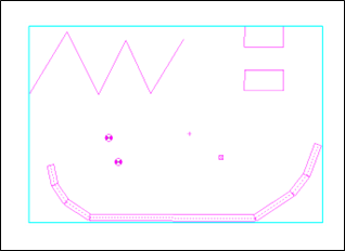
- Object tables can be filtered to show current multi-selection
- Toolbar | New icon
 for direct access to the appearance menu
 - Options | Appearance: New buttons “All” and “None” for activation / deactivation of appearance for all object types
- Options | Miscellaneous: New option to define color for currently multi-selected objects
- All point and polygon objects: Object snap when moving / creating polygon points while pressing the ALT key
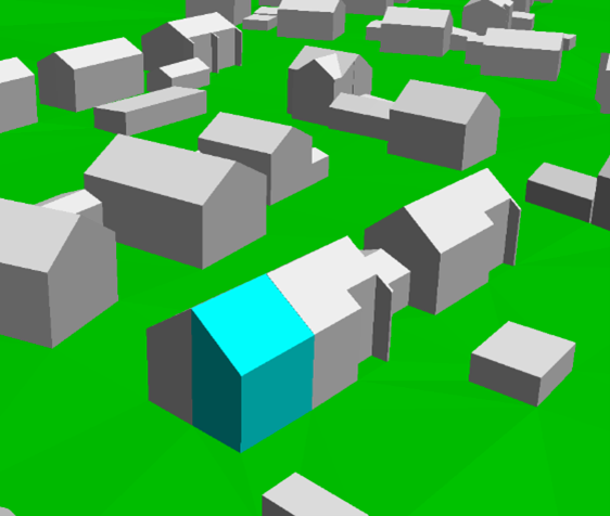
- CityGML import: New option to convert LoD2 data to LoD1 data while importing. For the height of the resulting LoD1 buildings, the average, maximum or minimum height of the individual sloped roof surfaces can be used
 |
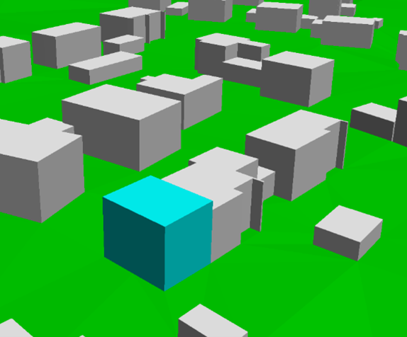 |
| LoD2-Daten ohne Konvertierung: Jedes Schrägdach als einzelnes Haus-Objekt | LoD2-Daten konvertiert nach LoD1 (mittlere Höhe) |
- Options | Appearance | Symbol: Length, Width and Angle of a symbol can now be entered as an expression. Examples:
- Show the main direction of the directivity of a point source depending on the attribute DIR_ANGLE
- Visualize the search radius of a crossing object depending on the attribute SEARCHRAD
- New function: Table | ”Copy group activation” to transfer the activation states in Table | Group to the current variant
- Menu Tables | Delete partial levels: New function to delete partial levels for the current / for all variants
- Modify Objects | Generate Building evaluation: New dialog to define settings for all building evaluations upon creation
- Crossing: Search radius for automatic assignment of roads to crossings can be defined by the user (before always 20m)
- Transformation between different zones now possible, e.g. to transform UTM data referenced in zone 33 into zone 32
- Color Palette (local/global) library: new button "Individual" enables to define classes individually (specification of lower/upper limits, class width, taking into account the actual number of colors of the color palette, adjusting the value range of the existing classes)
- Grid Appearance dialog: direct access to currently selected local color palette (enabling direct editing)
- Calculation | PCSP: Consistency check warnings are stored as local text blocks for each tile. After importing the results, all warnings including the tile number are available in the local library
- Function “Generate Terrain Contours from Height Points” can be executed without simplification of DTM with SHIFT+ALT+F12
- Grid | Arithmetics: If target grid (current variant) is not yet initialized, a warning message is shown
- Import | ESRI shape: Support for shp data with type 31 (MultiPatch)
- New Lua function
cna.import_citygml(path, building, dtm)for import of CityGML files with definition of corresponding settings - New Lua commands (read/write) to grid specification with
cna.grid.dx/dy/z/exclude_src/exclude_bld/exclude_bld_3D/use_limits - Transformation with NTv2 grids: definition of a user defined path via the ini file (Section [GeoCoordSys], variable NTv2Path=
)
Configuration Methods
- RLS-19: Road surfaces are now implemented as library object. This functionality can be used to define user defined road surface
- CNOSSOS-EU (Spain): Aerodynamic correction for default railway classes is now applied from > 249 km/h (previously: > 250 km/h)
- HJ 2.4 2009/2021: Calculation of foliage added for noise types industry and road (as ISO 9613-2 at 500 Hz)
- HJ 2.4 2009/2021: Calculation of Agr corrected when using method GB/T 17247.2. Calculation now always uses a frequency of 500 Hz
- HJ 2.4 2009/2021 | Configuration of Calculation: New option to select how Agr should be considered when calculating Abar with respect to single or multiple diffraction
- HJ 2.4 2021 Road/Railway: Consideration of negative path difference according to formula A.24 of HJ 2.4 - 2021 if 0>N>-0.2
- HJ 2.4 2021 railway noise: Function “Pass-by” not available anymore
- Configuration of Calculations | Tab Meteorology: Enter a user-defined north direction for consideration of meteorological effects
- Configuration of Calculations | General | Angle Scan Method: If activated, function “Pass-by” of individual vehicles is not available anymore
- Railway | FTA/FRA: For license configuration with FTA/FRA, calculation method Schall03 (1990) not included anymore
- Tables | Libraries | Absorptions: Sound absorption coefficients from "LAI-Hinweise zur Lärmkartierung - Dritte Aktualisierung vom 29./30.03.22" added to the default library
- Calculation | Multiple Source Effect: New option "DE 2020/367 (mittlere Werte Pegelband)" to take into account the level bands according to §5, Abs. 3b, 34. BImSchV
- Noise Mapping | Rounding according to 34. BImSchV / BEB (Germany): Detailed information in German version
Bug Fixes
- When importing .cna file with option "Import only section", objects of type Building Evaluation were not considered
- Progress bar was not shown correctly when importing big GML files
- When using a configuration template, the check for a calculation method is performed only if objects of this corresponding noise type exist in the project
- Fixed possible crash when importing data from WMS servers
- CityGML import: For some files, address data was not imported correctly
- Fixed possible crash when copying an object table including attribute MEMO
- Calculation | Configuration | Templates | sonRoad18: Check for ALFAL == 0.21 or RVL == 1.0 for buildings adjusted
- Excel-Import: When importing a cell with multiple text variables, the line break used in Excel with ALT+ENTER is now recognized correctly in CadnaA
- Pass-by function for noise type rail with definition of a rail penalty > 0: Calculation corrected
- ObjectScan | Preset „EU 2021/1226 – Residents - level classes (Median)“ now considers a threshold value of -66 dB
Attributes, Variables and Keywords
- Crossing: SEARCHRAD for automatic assignment of roads to crossings
- Road, RLS-19:
- Selection of road surface via attribute now with STRO_ID instead of STRONR
- Note: Attribute STRO (textual representation) is not available in combination with attribute STRO_ID
- Building, EINW: Input now with 3 decimals
- New attribute MULTISEL to allow modification of multi-selection via object-table and "Modify Object | Modify Attribute"
- Keyword
#(Time)now with optional parameter regarding format. Example:#(Time, HH_mm_ss)returns the current time in format 12_34_01