Object-Scan
The dialog Object-Scan on menu Grid is a powerful tool. The dialog enables to sum up for a selectable type of object an arbitrary attribute value or a calculated attribute value by a user-defined expression for all objects of the chosen type by the specified action.
Object Type
The summation occurs for the active variant and for the selected object type based on the object-specific attributes.
Action / Sum into
The adding and displaying of the final value can occur in the following ways:
Single Values
- As a target in „Action/Sum into“ select „Single Values“. The evaluation then takes place for the entire project file and the result value is displayed in a message dialog.
Specified Areas/Polygons
- As a target in „Action/Sum into“ select „Specified Areas/Polygons“. Then select a „Target Object Type“ to sum to. Furthermore, select an attribute of the selected „Target Object Type“ in which the values being summed up inside the closed polygon are assigned to.
Grid and Window Size
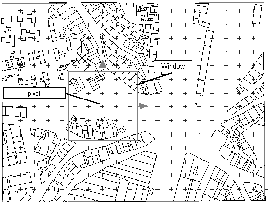
- As a target in „Action/Sum into“ select „Grid“ and as „Window Size“ define the length of a side of a square inside of which a result should be determined in a grid. This square is arranged so that its pivot is a grid point. The entire grid is run through in that way, by shifting the window step by step to the next grid point.
Table
- As a target in „Action/Sum into“ select „Table“. In this case, the evaluation takes place in a table either with user-defined intervals (min - max) of an arbitrary attribute or by predefined formulas (button „Predefined“).
Note
The procedures applying the available methods are described at the end of this chapter, each by an example.
As CadnaA enables to calculate up to four evaluation parameters simultaneously (see Evaluation Parameters Tab), the input boxes „Formula for Summation“ and „Formula for Total“ are identified by numbers „1“ to „4“. Based on the attributes of the object type selected up to four formulas can be evaluated at the same time.
Open the dialog Object-Scan on the Grid menu.
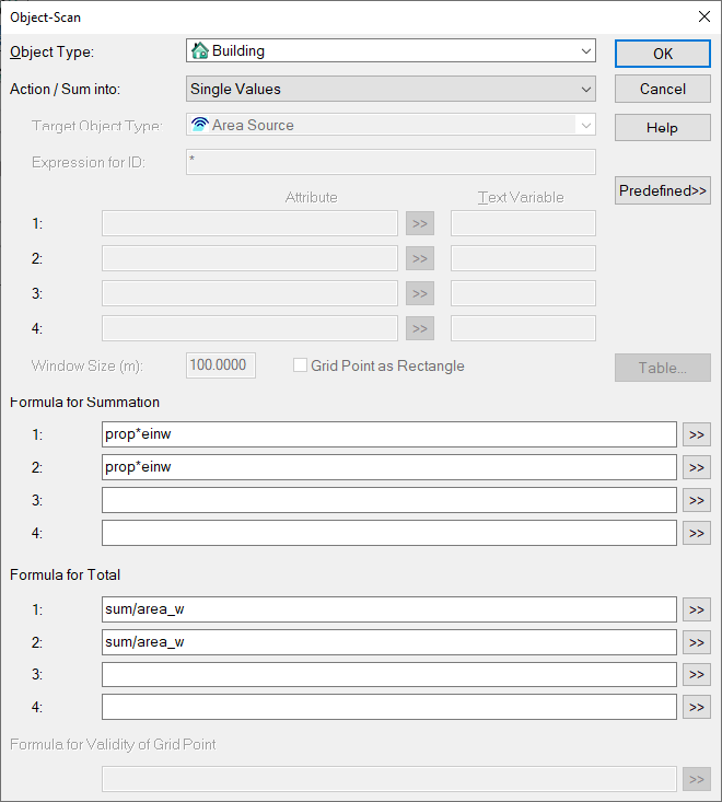
Target Object Type, Expression for ID, Attribute
Select the target object type when the option „Specified Areas /Polygons“ is selected in the list box „Action /Sum into“. The result is then written to the selected attribute (e.g. the name BEZ) of selected target object type (e.g. an area of designated use).
Note
Do not use the same attribute for another parameter 1..4 at the same time as the results will be overwritten in this case.
Window Size (m)
The input in box „Window Size (m)“ defines the side length of an invisible square within which a result on the grid is calculated (option „Grid“ selected for „Action /Sum into“). This scanning window is centered on each grid point as central point. The whole grid will be calculated by shifting iteratively the scanning window from grid point to grid point.
Grid Point as Rectangle
This option is only relevant for the summation of grid points in areas or in the grid. When checking whether a grid point lies within an area / a window, the corresponding rectangle of the grid point (instead of the x/y position of the point) is used. If rectangle and area or window intersect, the grid point is taken into account (even if it is outside the area/window).
Note
If activated, grid areas may be considered multiple times, as several areas / windows can intersect a grid rectangle.
Predefined
Via the button „Predefined“ evaluations with the corresponding formulas can be selected. The required settings are selected and the respective formulas pasted into the input boxes for „Formula for Summation“ and „Formula for Total“ for up to four evaluation parameters (including the table settings).
- EU 2002/49/EC, Annex VI EU2002/49/EG-2002
- People in level classes
- People w/ quiet facade - Classes
- People w/o quiet facade - Classes
- People w/ quiet facade (limit. val.) - Classes
- People w/o quiet facade (limit. val.) - Classes
- Grid area in level classes
- EU 2015/996: People in level classes (Single Dwelling) (see also EU-2015, CNS-DE-2021, ÖAL28-2021 and EU: Single Dwelling below)
- EU 2020/367: Ischeamic heart disease (IHD), HA and HSD (EU-2020)This template requires the prior calculation via the menu „Multiple Source Effect“, see Multiple Source Effect. The value 1.0 given under „Formula for result“ describes the incidence rate Iy according to section 3.2.3 and must be adjusted depending on the project region.
- EU 2021/1226 (EU-2021)
- People in level classes (Median) (see also CNS-DE-2021, ÖAL28-2019)
- Noisiest grid point in/near building, step 1 and 2 (see also CNS-DE-2021 and EU 2021/1226: Noisiest grid point in/near building)
- Quietest grid point near building, step 1 and 2 (see also CNS-DE-2021 and EU/DE 2021/1226: Quietest grid point near building)
- DE 2021/1226 (BEB 2021):- available in German documentation only -
- DE 2002/49/EC, Annex VI (BEB 2021): - available in German documentation only -
- VBEB / BEB 2018: People in level classes (see also VBEB-2006, CNS-DE-2018)
- Building Heights from Points
- LEG/km2 (similar to Noise Impact Ranking NIR)
Note
Further hints regarding expressions for evaluations can be found in the CadnaA manual „Attributes, Variables, and Keywords“, see Object Scan.
Save as
User defined settings on the dialog Object-Scan can be saved. Select the command Save to at the lower end of the default entries and enter a name. When using backslash "\" within the name, the user can create a sub-menu or - if already existing - add an entry to this sub-menu.
Note
The user defined settings are saved in the CadnaA installation directory in the file objscan.ini. Regarding the file path see Installing CadnaA, INI-files, in the manual „Introduction to CadnaA“.
Delete
User defined settings can be deleted again (via button „Predefined“, command Delete). Select the corresponding name. The respective settings are deleted without safety request.
Formula for Summation
Enter in input boxes 1 to 4 an expression or select parameters from the list of attributes (button „>>“). By this, you determine which value will be added up for each object detected during the scanning operation.
List of Attributes
The list of attributes opens by clicking the double-arrow button (>>). Only the attributes of the selected object type are displayed. To select and insert an attribute just click on it. To overwrite an existing expression, activate/select the present expression and select a new attribute from the list.
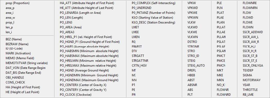
List of Attributes on dialog Object-Scan (here for object „Road“)
Variable
The list of attributes is separated by a horizontal line. The attributes below this line are object specific (see the CadnaA-manual "Attributes, Variables, and Keywords", Table Object Attributes). Above this separating line special attributes are listed used for object-scanning.
| prop | part of the object which is inside the window. With extended objects it is the proportion of the area; with line objects the proportion of the length. |
| area_p | total area of an object (by closed polygons) |
| area_i | area of an object which lies inside the window |
| area_w | area of the window, (Window Size)² when summing into the grid |
| prop_l | proportion of the length of open or closed lines which are lying inside the window (well in distinction to "prop" with areas determined by the proportion of the perimeter) |
| len_p | total length of an open or closed line (therefore also the perimeter line of an area) |
| len_i | length of the part, of an open or closed line, which is lying inside the window |
| int_lo | lower limit of an interval (when summing up into a table) |
| int_hi | upper limit of an interval (when summing up into a table) |
Formula for Total
An entered expression determines how the value resulting from the „Formula for Summation“ are processed further. By default, the following variables apply:
- sum, sum1..4: The value resulting from the „Formula for Summation“ are summed up.
- max, max1..4: The maximum value of the values „Formula for Summation“ results from the scan.
- min, min1..4: The minimum value of the values „Formula for Summation“ results from the scan.
- area_w: area of the scanning window (in m²)
- num: total number of objects scanned
Any combinations of these variables can also be defined using the operators as conventional.
Note
An overview and a description of all variables for „Formula for Total“ provides the CadnaA-manual „Attributes, Variables, and Keywords“, Object Scan)
Examples of Expressions
- to sum up the total length (in metres) of the roads in a project use the following settings:
| Object Type: | Road |
|---|---|
| Action/Sum in: | Single Values |
| Expression in „Formula for Summation“: | len_p |
| Expression in „Formula for Total“: | sum |
- to sum up the total length (in kilometres) of the roads in a project use the following settings:
| Object Type: | Road |
|---|---|
| Action/Sum in: | Single Values |
| Expression in „Formula for Summation“: | len_p |
| Expression in „Formula for Total“: | sum/1000 |
- or
| Object Type: | Road |
|---|---|
| Action/Sum in: | Single Values |
| Expression in „Formula for Summation“: | len_p/1000 |
| Expression in „Formula for Total“: | sum |
- to sum up the total number of residents inside buildings in a project use the following settings:
| Object Type: | Building |
| Action/Sum in: | Single Values |
| Expression in „Formula for Summation“: | iif(WG_NUM, EINW,0) (in words: if it is a residential building, sum up the residents, otherwise add zero) |
| Expression in „Formula for Total“: | sum |
- to sum up the total floor area of buildings use the following settings:
| Object Type: | Building |
| Action/Sum in: | Single Values |
| Expression in „Formula for Summation“: | iif(WG_NUM, area_p,0)*PO_HREL_P1/3 (in words: if it is a residential building, add the ground area of the buildings, otherwise not and multiply the total area with the relative height of the first building point for each building divided by 3 m, assuming that the average floor height is 3 m) |
| Expression in „Formula for Total“: | sum |
Formula for Validity of Grid Point
This setting is only relevant if "Action / Sum into" = Grid is selected. Invalid grid points can be present, for example, if a grid point is located in a building and the grid setting "Exclude Buildings" is active. If such an inner grid point is to be assigned a new value via the Object-Scan, it must first be defined as valid. The following cases are distinguished:
- Formula for Validity == 0 or <none>: There is no change to the validity of grid points. An invalid grid point remains invalid, a valid grid point remains valid.
- Formula for Validity > 0: Invalid grid points become valid.
- Formula for Validity < 0: Valid grid points become invalid.
Note
The formula for validity is used, for example, with the preset "EU/DE 2021/1226: Quietest grid point near building, step 2" to ensure correct evaluation of areas in houses.
Example
When entering the formula iif(sum1>0,1,0), only grid points for which the summation is > 0 are defined as valid in the model. All other grid points are invalid.
Calculation
After completing the inputs start the object scanning by clicking OK.
A result dialog is displayed when summing up into single values. With summation into areas or grid, the target objects or the grid contain the resulting values. When summing into a table the results are displayed in tabulated format.
Textblock
The scanning results are automatically written to a local text blocks named OBJSCAN1...4 (see menu Tables|Libraries (local)|Textblocks).
These text blocks can be used in reports, legends, or in export files, for example (see Text Blocks).
When several scans with different expression of evaluation are carried out after each other, first rename the respective text block/s prior to a new scan. Otherwise the existing text block will be overwritten with a new scan.
Renaming Text Blocks
After having determined the total road length in kilometers the respective text block is renamed (e.g. to „L_road“). With a new scan, CadnaA creates a new text block OBJSCANx.
Displaying Text Blocks
The scanning result can be displayed in a text frame based on the text block. To achieve this establish, for example, a reference to text block OBJSCAN 1 as follows:
Road Length = #(Text, OBJSCAN1) km
EU: Single Dwelling
This section is only revelent when using the preset „EU: People in level classes (Single Dwelling)“. Above mentioned directives / standards include an additional condition regarding the evaluation of facade levels. The text from EU-2015, condition e is given as an example:
„Only for buildings with floor sizes that indicate a single dwelling per floor level, the most exposed facade noise level is directly used for the statistics and related to the number of inhabitants.“
This condition is implemented in CadnaA with a variable in a local text block and, if necessary, a memo variable for each building:
Local text block defines minimum floor area
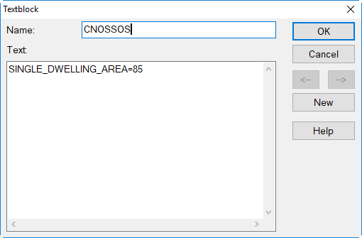
By default a minimum floor area of 70 m² applies. Any other minimum floor area can be defined using a local text block (see Text Blocks) with the name „CNOSSOS“. For example, by the text
SINGLE_DWELLING_AREA=85
a minimum floor area of 85 m² is applied as a condition to execute the above mentioned, different evaluation of buildings with just a single dwelling per floor level.
String Variable "Single Dwelling"
Regardless of this condition for the minimum floor area, by the string variable of the building evaluation
CNOSSOS_SINGLE_DWELLING
it can be specified whether all floors of the associated building consist of a single dwelling per floor level or not (with values 0=no or 1=yes). The string variable
CNOSSOS_SINGLE_DWELLING=1
will cause the resulting level LPCNOSSx to correspond with the maximum facade level for each floor LPFLMAXx, otherwise the facade level at the actual facade point LPx is used in the evaluation.
When scanning for inhabitants in those buildings the attribute LPFLMAXx has to be used (instead of LPCNOSSx), thus requiring two scans, one for each type of building while the other type is deactivated. The sum of the inhabitants from the two scans gives the entire number of inhabitants per level class.
EU 2021/1226: Noisiest grid point in/near building
According to EU-2021, for „the assessment of buildings not containing dwellings and exposed to aircraft noise, each building is associated to the noisiest noise receiver point falling within the building itself or, if not present, on the grid surrounding the building.“. A more detailed definition, which grid points to be considered, is not given in EU-2021.
In CNS-DE-2021 and especially in the corresponding test cases the procedure to be applied for Germany is more specified. The method implemented in CadnaA and described below follows this definition. Following steps have to be carried out:
-
Calculate grid for Lden and Ln
-
Execute Object-Scan preset „EU 2021/1226: Noisiest grid point in/near building (Step 1)“. In this process, all grid points are determined whose area (e.g. square of 10x10m) is intersected by the polygon of the building. Among the corresponding grid points, the maximum value for each evaluation parameter is determined and written into the memo variables MAX_LP1...MAX_LP4.
-
Execute Object-Scan preset „EU 2021/1226: Noisiest grid point in/near building (Step 2)“.This template is similar to "EU: People - Classes", but the previously created memo variables MAX_LP1...LP4 (instead of the attributes HB_LP1...LP4) are used.
EU/DE 2021/1226: Quietest grid point near building
According to EU-2021, „grid points that are located inside buildings shall be assigned a noise level result by assigning the quietest nearby noise receiver points outside buildings, except for aircraft [...]“. A more detailed definition, which grid points to be considered, is not given in EU-2021.
In CNS-DE-2021 and especially in the corresponding test cases the procedure to be applied for Germany is more specified. The method implemented in CadnaA and described below follows this definition. Following steps have to be carried out:
-
Setting „Extrapolate Grid ‚under‘ Buildings“ in the configuration of calculations must be activated. Setting „Exclude Buildings“ at grid specification must be activated.
-
Calculate grid for Lden and Ln
-
Save grid locally via menu „Grid | Save as...“
-
Execute Object-Scan preset „EU 2021/1226: Quietest grid point near building (Step 1)“In this process, all grid points with x/y-position inside buildings are determined. For each grid point, the minimum value of the 8 neighbouring grid points is calculated and written into the memo variables MIN_LP1...MIN_LP4.
-
Execute Object-Scan preset „EU 2021/1226: Quietest grid point near building (Step 2)“Grid points inside the building are assigned the previously determined value MIN_LP1...MIN_LP4 per target size. Grid points outside the buildings receive the value 0.
-
Save grid locally via menu „Grid | Save as...“
-
Open Menu „Grid | Arithmetics“ and assign grid of step 3 to R1 and grid of step 6 to R2. For all relevant evaluation parameters, enter the formula iif(R2>0,R2,R1) and execute with „OK“. The setting „New Grid is Intersection of Input Grids“ must be inactive.
-
The summation of the grid areas is finally done via the Object-Scan preset "EU: Grid Area - Classes".
Note
The formula „LPx_MIN8“ used in step 4 is also implemented for the maximum value („LPx_MAX8“), but not relevant for this procedure.